Homeland Properties
402 US Hwy 190 E
Commercial, Commercial Lease, Walker County
402 US Hwy 190 E, Huntsville, Texas 77340
Listing ID: 61895
$5,000 per month
Property Description:
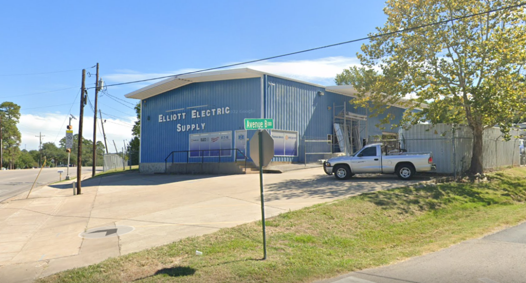
Commercial Lease Space Available!
Sitting on 1.53 Acres with a stabilized fenced yard.
Excellent location and exposure fronting Hwy 190
1,250 SqFt office space & 3,500 SqFt warehouse building. Combined totaling 5,000 SqFt.
3 year lease required – Tenant Occupied until July 31 2024
Other Details
Showing/Viewing Instructions:Buyer &/or agents must notify Homeland Properties of intent to view/tour & make advance appointment.
Tenant occupied until June 2024
Directions:From Sam Houston Ave head Southeast toward Montgomery Rd. Turn right onto Montgomery Rd, in .5 miles turn right onto Bowers Blvd. In .3 miles turn left onto Sycamore Ave and in .8 miles turn right onto Phelps Dr, the destination will be on your right.
Access/Frontage:Hwy 190
Utilities:Electricity, Public Sewer, Public Water
Utility District(s):Entergy, City of Huntsville WSC
School District:Huntsville ISD
Disclaimers
Listing Disclaimer:The use and/or reproduction of any marketing materials generated by HomeLand Properties, Inc. and/or its associated clients, including, but not limited to, maps, videos, photos, spreadsheets, diagrams, contracts, documents, etc. is strictly prohibited without written consent. The information contained herein is from sources deemed reliable but is not guaranteed by HomeLand Properties, Inc. The offerings are subject to change in price, errors, omissions, prior sales or withdrawal without notice. This disclaimer supersedes any & all information published by other MLS sites whether by permission or not, including, but not limited to, co-broker fees, if any. Acreage size and dimensions are approximate. County Appraisal District (CAD) market and tax values, as well as acreage size and/or shape, are not applicable to real estate market conditions and/or this solicitation, other than for ag value (1D1) purposes.
Legal Disclaimer:Size is approximate and subject to recorded legal description or surveyed gross acres to include, but not limited to, any acres lying within roads & easements. CAD shape files are not reliable. Shape files per maps herein are considered the most accurate available and are derived using the best information available, included, but not limited to, GIS data, field data, legal descriptions, and survey, if available.

Property Photos:
Showing/Viewing Instructions:Buyer &/or agents must notify Homeland Properties of intent to view/tour & make advance appointment.
Tenant occupied until June 2024
Directions:From Sam Houston Ave head Southeast toward Montgomery Rd. Turn right onto Montgomery Rd, in .5 miles turn right onto Bowers Blvd. In .3 miles turn left onto Sycamore Ave and in .8 miles turn right onto Phelps Dr, the destination will be on your right.
Access/Frontage:Hwy 190
Utilities:Electricity, Public Sewer, Public Water
Utility District(s):Entergy, City of Huntsville WSC
School District:Huntsville ISD
Listing Disclaimer:The use and/or reproduction of any marketing materials generated by HomeLand Properties, Inc. and/or its associated clients, including, but not limited to, maps, videos, photos, spreadsheets, diagrams, contracts, documents, etc. is strictly prohibited without written consent. The information contained herein is from sources deemed reliable but is not guaranteed by HomeLand Properties, Inc. The offerings are subject to change in price, errors, omissions, prior sales or withdrawal without notice. This disclaimer supersedes any & all information published by other MLS sites whether by permission or not, including, but not limited to, co-broker fees, if any. Acreage size and dimensions are approximate. County Appraisal District (CAD) market and tax values, as well as acreage size and/or shape, are not applicable to real estate market conditions and/or this solicitation, other than for ag value (1D1) purposes.
Legal Disclaimer:Size is approximate and subject to recorded legal description or surveyed gross acres to include, but not limited to, any acres lying within roads & easements. CAD shape files are not reliable. Shape files per maps herein are considered the most accurate available and are derived using the best information available, included, but not limited to, GIS data, field data, legal descriptions, and survey, if available.